|
Such beautiful places do you usually only find at unpaved, small sideroads.
Just outside Winneway did I get on one of the worst roads I've ever been
on. It's been that rough that I couldn't even switch to the second gear.
As two Algonquin first nations told me later has that track been made of
creek bed rocks. No wonder.
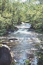
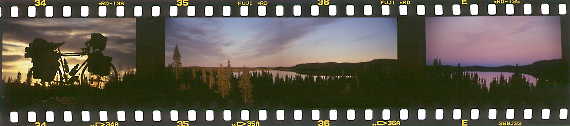
Rapide Sept. Put up my camp right at a dam on a nice green spot. Next morning, looking
out of my tent straight on the lake - could I not resist. I just needed to
jump into it.
|
|
Further north on the Route de la Baie James towards Radisson
...
Looking for a nice spot to camp. Some tracks turn off the highway to the
left and disappear somewhere between bushes. That's what I was looking for.
Follow 'em but don't need to go very far. The tracks pass by the ridge
of a gravel pit and let me have a superb view of the surrounding. I follow
the edge a few more meter and got a beautiful camping spot for the night.
It's a fantastic evening.
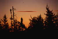
Sittin' in front of the tent, watching the clouds move by, the changes of
the color of the sky from blue to pink to dark orange, the sun going down,
listening to the birds and the wind, enjoying the fresh cold wind on my face
and the beautiful scenery all around me.
The happiest man on earth.
|
The land up north is the land of the
Cree
first nations.
As most first nations do they live in reservations too. But they've got a
little advantage compared to others. Their original home - the huge, endless
taiga of central Quebec - is almost uninhabited. So it's no surprise that
quite some Cree still live the traditional way and head out each summer to
go fishing and trapping.
Route de la Baie James
from: Matagami
to: Radisson
distance: 625km
paved all the way through
services: km 381 (Relais 381)
easy cycling
|
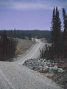
Route du Nord
from: Route de la Baie James, km 274
to: Chibougamau
distance: 437km
gravel all the way
services: km 112 (Nemaska); 10km off
very tough cycling; a lot of steep hills
NO NEWBIES !!
|
The Route du Nord is dividable into three stages with different
difficulties. The first to Poste Albanel (km 148) is more or less flat.
The second one is the one that makes this route that demanding. For about
a hundred kilometer will you find nothing else than ups 'n' downs. You'll
have to get over close to 50 hills on those 100km. Grades? None less than
8%, most somewhere between 9% and 11% and still a couple with 12% and more.
Though you won't be able to relax on the remaining kilometer, do the number
of hills and their grades decrease ...
Only leaves me to wish you dry weather. 'Cause you for sure wouldn't want to cycle
this route in anything else. :-)
|
|
There've also been a lot of interesting places and sceneries on my trip
further on towards Tadoussac and Baie Cameau. But because there's lots
of info on those regions available on the net and in books do I leave
them out and continue after I left Baie Comeau.
on the way to Manic Cinq
|
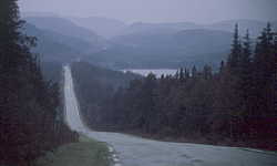
Route 389
from: Baie Comeau
to: border Labrador
distance: 570km
B.C. - Manic Cinq and Gagnon - Fire Lake: paved
. . . the rest: gravel
services: km 22, km 95, km 212 (Manic 5)
. . . km 316, km 561 (Fermont)
not difficult; but very hilly at the beginning
|
coming up ... Labrador
Labrador - a lot of people already tried to describe it, to capture
it. With travelogues, with photos, with scenery descriptions.
Succeeded has hardly anyone.
Labrador cannot be captured, it can only be experienced;
if you slowly approach to it - mentally and physically.
'Cause then captures Labrador you - and you'll realize,
Labrador is only on the verge a spot on the map ...
|
|
Labrador is a way of life
|
|
as Siberia, as Outback Australia.
|
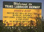
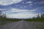
Trans Labrador Highway
from: border Quebec
to: Goose Bay
distance: 558km
gravel, sand, rocks
services: Labrador City (km 17)
. . . Churchill Falls (km 265)
very tough cycling
NO NEWBIES !!
|
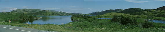
Newfoundland
do you reach from Goose Bay - except by plane - only by boat.
The time I came through there have been two ferries run by Marine Atlantic. Now
are they run by the Government.
One runs between Goose Bay and Lewisporte via Cartwright, the
other one up and down the coast between St. Anthony and Nain.
That's the official stuff.
But there's also another possibility. It's a chartered barge. No reservations, no
schedule.
It just cruises up and down the coast and stops by wherever it's necessary to get freight on board / drop it off. If you happen to be at the quay at
that time and ask for a passage ... "sure, why not?"
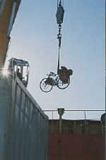
Actually, I didn't make it to Newfoundland. I left the barge- my bike "flew"
off - in Red Bay. And that's still Labrador. 'Cause from here you can continue
on cycling to Newfoundland.
|
|
|
... hasn't experienced anything like that before ...
|
but now ... Newfoundland ... or not?
No, at least will I not give any particular information right here.
By far the most cyclists stick to the TCH. Nothing else. Maybe with a short
side trip to the Gros Morne NP. That's it.
FOLKS, you'll see as much of Newfoundland by cycling the TCH as if you'd
cross your country on a superhighway!!!
a hint
for all those, who love Newfoundland, for those who would like to get (and
keep) all kinds of impressions of the nature and the people; and those, who'd
like to see and experience the 'real' Newfoundland ... , let the fantasy be your
guide, turn off, ask around, try out, ... , you're in Newfoundland!
Everything's still possible here!!
A bit more detailed? The ferries along the south coast open up nice options. Including trips straight through "the middle" of Newfoundland. North coast? How about connecting one dead end road with the next one? Some are only a few hundred meters of water apart. Or how about the old railway? I don't know if it's an official bike path by now or not - but it's a very interesting ride in any case!
|